How To Find Your Property On FEMA’s Flood Insurance Rate Maps

What are FEMA flood maps?
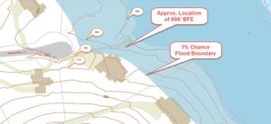
FEMA’s Flood Insurance Rate Maps (FIRMs) or just Flood Maps are provided after a flood risk assessment has been completed or updated for a community.  This study is known as a Flood Insurance Study.  The FIRM gives you the Base Flood Elevations (BFEs) and insurance risk zones in addition to floodplain boundaries.  The FIRM may also show a delineation of the regulatory floodway.

Once the “insurance risk zone”  (commonly referred to as the flood zone) is determined, actuarial rates, based on these risk zones, are then applied for newly constructed, substantially approved, and substantially damaged buildings.  FEMA uses these rates to determine the insurance rate you will pay for flood insurance

FEMA’s Digital Flood Maps

FEMA discontinued the production and distribution of paper flood maps in 2009 as part of its Digital Vision Initiative. This affected all the Flood Maps, boundary information, and study reports. However, clients can still view the products for free through their website or buy them in digital format.

To view these flood maps online, go to FEMA’s Map Service Center and key in your address (hi-lited area shown here) search for your home.  This will prompt you to then select the map that covers your area.  The Flood Maps are somewhat cumbersome to use online. It is best to go through the tutorial on the bottom right of the address search page for an easier and more effective use of the GIS map.
author avatar
Surveyor

More Posts

Aerial view of homes with blue FEMA flood zone overlays showing areas where an elevation certificate can prove reduced flood risk
flood damage
Surveyor

How an Elevation Certificate Can Remove Flood Zone Risk

If you live in Columbus, chances are you’ve heard about flood zones. Homeowners near the Chattahoochee River, Weracoba Creek, or Lindsey Creek often get letters from lenders saying they must carry flood insurance. For many families, that extra cost can feel overwhelming. The good news is that you may not

Read More »
Boundary line survey example showing residential homes with a shared fence and potential property line dispute
boundary surveying
Surveyor

Boundary Line Survey Solutions for Property Disputes

Buying or owning property should feel exciting. Yet for many homeowners, the experience can quickly turn stressful when property lines aren’t clear. One neighbor claims the fence is too far over, while the other swears the deed supports their side. Sometimes, the problem shows up even later—at the closing table—when

Read More »
Surveyor using a total station during an ALTA survey on open land in Newnan
alta survey
Surveyor

What the First 24 Hours of an ALTA Survey Reveal 

When your ALTA survey is finally complete, you might think the hard part is over. But in reality, the next 24 hours could be some of the most important hours of your entire property journey. This short window is when the survey’s findings are fresh, your surveyor’s notes are still

Read More »
Boundary survey helps resolve property dispute in Georgia after a tree falls and damages a neighbor's garage.
boundary surveying
Surveyor

Boundary Survey Solves Tree Damage Dispute Between Neighbors

If you’ve ever lived in a neighborhood with tall old trees and unclear property lines, you know how quickly peace can turn into property disputes — especially when a tree falls. In Georgia, where summer storms and aging oaks are common, fallen tree damage can spark more than just cleanup

Read More »