How To Find Your Property On FEMA’s Flood Insurance Rate Maps

What are FEMA flood maps?
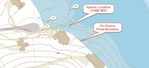
FEMA’s Flood Insurance Rate Maps (FIRMs) or just Flood Maps are provided after a flood risk assessment has been completed or updated for a community.  This study is known as a Flood Insurance Study.  The FIRM gives you the Base Flood Elevations (BFEs) and insurance risk zones in addition to floodplain boundaries.  The FIRM may also show a delineation of the regulatory floodway.

Once the “insurance risk zone”  (commonly referred to as the flood zone) is determined, actuarial rates, based on these risk zones, are then applied for newly constructed, substantially approved, and substantially damaged buildings.  FEMA uses these rates to determine the insurance rate you will pay for flood insurance

FEMA’s Digital Flood Maps

FEMA discontinued the production and distribution of paper flood maps in 2009 as part of its Digital Vision Initiative. This affected all the Flood Maps, boundary information, and study reports. However, clients can still view the products for free through their website or buy them in digital format.

To view these flood maps online, go to FEMA’s Map Service Center and key in your address (hi-lited area shown here) search for your home.  This will prompt you to then select the map that covers your area.  The Flood Maps are somewhat cumbersome to use online. It is best to go through the tutorial on the bottom right of the address search page for an easier and more effective use of the GIS map.

author avatar
Surveyor

More Posts

Why First-Time Landowners Need a Land Surveyor

Buying land for the first time in Carrollton GA is a major milestone but it comes with hidden risks many new landowners overlook. From unclear boundaries and zoning restrictions to access issues and permit delays, one small mistake can lead to big problems. That’s why working with a qualified land

Read More »

How ALTA Surveys Resolve Title Issues in Savannah GA

Transitional land in Savannah offers big opportunities—but also hidden risks. An ALTA Survey in Savannah, GA is often the key to uncovering those risks early. As older properties shift toward commercial or mixed-use developments, questions about ownership, access, and legal boundaries can arise. Without clarity, these issues can delay or

Read More »

LiDAR Mapping in Construction Surveying

Why Construction Surveying Is Evolving Construction projects today are moving faster than ever, and accurate data is key to keeping them on track. Traditional tools like total stations and GPS are still useful, but they’re no longer the only options. One technology that’s rising fast in the industry is LiDAR

Read More »

Why LiDAR Mapping Matters in LaGrange, GA

In recent years, LiDAR has moved beyond government and research settings. Now, small businesses, developers, and local companies in LaGrange, Georgia, are seeing its real-world value. As we step into 2025, LiDAR Mapping in LaGrange GA is no longer a luxury—it’s becoming a necessity. Overview of the Business Landscape in

Read More »