LiDAR mapping is quickly becoming one of the most reliable tools for preventing drainage and erosion issues in both residential and commercial developments. By capturing highly accurate elevation data, it helps builders, engineers, and property owners understand how water flows across a site—before costly problems arise.
Whether you’re planning new construction or trying to solve existing runoff concerns, LiDAR mapping gives you the insights needed to design effective grading, drainage, and erosion control systems with confidence.
Understanding Drainage and Erosion Challenges in Newnan
🌧️Common Causes of Erosion
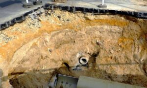
Newnan’s natural landscape features rolling hills, clay soils, and frequent rainfall—especially during the spring and summer. These conditions, combined with land clearing or grading for new construction, create the perfect setup for erosion. Water runs off slopes faster than the soil can absorb it, carrying sediment and damaging nearby structures or roads. One of the best ways of preventing erosion with elevation data is by identifying risk areas early and addressing runoff before construction begins.
🏠 Impact on Residential and Commercial Land
In residential areas, poor drainage can lead to water pooling around foundations, soggy lawns, or even basement flooding. Commercial properties may see runoff damaging parking lots, flooding entrances, or causing long-term wear on infrastructure. Once erosion starts, it becomes more expensive to fix.
Using LiDAR to Identify At-Risk Areas
📍Mapping Slopes, Channels, and Low Points
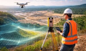
With LiDAR, planners can easily spot high and low areas, steep slopes, and natural drainage channels. These maps are accurate down to a few centimeters—meaning even subtle grade differences that could lead to erosion are detected early.
🌊Detecting Drainage Patterns Before They Become a Problem
Instead of waiting for water to cause damage, LiDAR mapping for drainage planning allows engineers to model how water will flow during heavy rain. They can predict ponding areas, overflow paths, and risk zones—then design solutions in advance.
Applications in Newnan Construction and Landscaping
1. Site Planning and Grading for New Homes
Builders in Newnan are using LiDAR to plan home elevations, driveways, and drainage swales before breaking ground. This ensures proper runoff and prevents water from flowing toward homes or neighboring properties. With accurate data, they can develop smarter site grading and runoff control solutions that reduce the risk of erosion and drainage issues from day one.
2. Stormwater Management for Commercial Developments
Commercial developers use LiDAR to design retention ponds, curb systems, and underground drainage that meet city regulations. The detailed data helps with grading plans, trenching routes, and avoiding costly rework due to drainage failure.
Supporting Retention Pond and Swale Design
- Ensuring Proper Sizing and Placement. A poorly placed or undersized retention pond will overflow, causing erosion downhill. With LiDAR, engineers can design ponds and swales that match the terrain and control stormwater effectively—even after heavy rains.
- How LiDAR Prevents Overflow and Erosion Downstream. By simulating runoff with accurate elevation data, LiDAR helps plan systems that slow water down and prevent soil displacement. This is key to long-term erosion control in neighborhoods, business parks, and along roadways.
Integrating LiDAR Data with Civil Engineering Tools
- Digital Elevation Models (DEMs) and 3D Site Modeling. LiDAR data can be imported into design tools like CAD and GIS platforms to create realistic terrain models. These models guide everything from pipe placement to driveway slope, making every inch of the land work smarter.
- Smoother Planning and Permitting with GIS. Newnan’s permitting process often requires grading plans or stormwater reports. With LiDAR-backed models, civil engineers can present detailed, compliant documentation that speeds up approvals and supports local regulations.
LiDAR’s Role in Flood Risk Reduction and FEMA Compliance
Mapping Flood Zones More Accurately
FEMA flood maps don’t always show precise elevation details for individual lots. With LiDAR mapping, surveyors can produce accurate floodplain overlays, helping owners determine if flood insurance or an elevation certificate is required.
Supporting Elevation Certificates and Risk Assessments
For properties near lakes, creeks, or low areas, LiDAR helps produce elevation certificates that satisfy FEMA and insurance providers—often lowering costs or removing the flood zone classification altogether.
Choosing the Right LiDAR Survey Provider in Newnan
What to Look For in a Service Team
- Local experience with Georgia soils and drainage challenges
- Access to drone-based LiDAR equipment
- Ability to deliver GIS-ready maps and 3D models
- Knowledge of Coweta County building and drainage codes
Local Knowledge and Regulation Awareness
A provider familiar with Newnan’s terrain and permitting rules will be better equipped to guide your project, from pre-construction surveys to erosion control plans.
FAQs About LiDAR for Erosion and Drainage Projects
1. Can LiDAR mapping help stop erosion on sloped lots?
Yes. It helps identify where runoff will concentrate, so erosion control can be planned in advance.
2. Is LiDAR useful for residential landscaping?
Absolutely. Even for grading a backyard or placing swales, LiDAR gives landscapers accurate slope data.
3. How fast can I get a LiDAR survey done in Newnan?
Most small projects are completed within a few days, with results ready for engineers shortly after.
4. Does LiDAR replace traditional surveying?
Not entirely, but it enhances it—especially when terrain detail or elevation data is key.
5. Can it help with FEMA flood zone appeals?
Yes. LiDAR can be used to support elevation certificates or provide better ground models for appeals.
6. Is LiDAR cost-effective for small builders?
Yes. The cost is often lower than the price of fixing drainage mistakes or failing inspections.
