Urban development in Georgia is changing fast, thanks to LiDAR (Light Detection and Ranging). This advanced technology helps city planners, developers, and government officials create detailed 3D maps. These maps make it easier to plan better roads, buildings, and public spaces, while also helping to prevent problems like flooding.
From the busy streets of Atlanta to the historic neighborhoods of Newnan, LiDAR is shaping the future of Georgia’s cities. Let’s take a closer look at how this high-tech tool is making urban planning smarter and more efficient across the state.
What is LiDAR and How Does It Work?
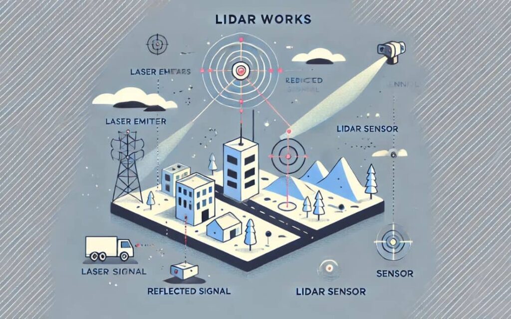
LiDAR is a technology that uses lasers to measure distances and create detailed 3D maps of cities and landscapes. It can be placed on drones, airplanes, or ground vehicles to scan the environment and collect data. This helps city planners understand the land, trees, buildings, and possible dangers like flood zones or unstable ground.
Key Features of LiDAR in Urban Planning:
- High Accuracy – Produces precise elevation and topographical data.
- Rapid Data Collection – Captures large areas quickly and efficiently.
- Penetrates Vegetation – Helps analyze landscapes beneath tree canopies.
- Works in Various Conditions – Operates day or night, even in low-visibility areas.
How LiDAR Supports Urban Development in Georgia
1. Smart Zoning and Land Use Planning
LiDAR’s ability to generate detailed topographical data helps in identifying the best locations for new housing, commercial spaces, and public areas.
- Atlanta and Savannah use LiDAR to assess elevation changes, drainage patterns, and vegetation cover, ensuring sustainable land use.
- The technology helps identify flood-prone areas and prevents construction in unsuitable locations.
2. Infrastructure Development and Maintenance
Maintaining and upgrading infrastructure is essential for Georgia’s growing population. LiDAR provides city planners with:
- Accurate road condition assessments for smoother transportation planning.
- 3D models for utility placements (sewer, water, and electrical lines).
- Insights into public space development, ensuring pedestrian-friendly environments.
The Atlanta Regional Commission (ARC) integrates LiDAR mapping to improve transportation networks and optimize long-term investments in roads and highways.
3. Flood Risk and Disaster Mitigation
Georgia faces frequent flooding, particularly in low-lying areas like Newnan. LiDAR assists in:
- Identifying flood-prone zones and guiding the construction of drainage systems.
- Modeling stormwater flow to prevent damage to residential and commercial properties.
- Enhancing emergency response planning by mapping out vulnerable neighborhoods.
This is particularly relevant in Newnan, GA, where managing stormwater is a priority for city planners.
4. Preservation of Historical and Green Spaces
Georgia is home to many historic districts and green spaces that require protection from uncontrolled urbanization. LiDAR technology supports preservation efforts by:
- Mapping historical structures to track potential structural damage.
- Monitoring tree canopies to protect the natural environment in cities like Newnan.
- Preventing unchecked development in culturally significant areas.
By using LiDAR, urban planners ensure that Georgia’s rich history and natural beauty remain intact while accommodating modern growth.
Case Study: Atlanta’s Use of LiDAR for Smart Urban Growth
Atlanta has embraced LiDAR technology to improve urban planning and development. The city utilizes LiDAR to:
- Create digital twins—virtual models of the city for planning and simulation.
- Simulate traffic flow and congestion patterns, optimizing road expansions.
- Analyze building heights and shadow impacts to maintain livability.
This approach has allowed Atlanta to grow sustainably, balancing development with environmental conservation.
LiDAR Mapping Benefit for Newnan
As Newnan continues to expand, integrating LiDAR into urban planning can offer multiple advantages:
- Optimized Land Use – Identifying the best locations for housing and businesses.
- Improved Traffic Flow – Using LiDAR data to design better road networks.
- Enhanced Flood Prevention – Mapping stormwater patterns for improved drainage systems.
- Historic Site Protection – Tracking the structural integrity of historic buildings.
LiDAR is helping cities in Georgia grow smarter and safer. It helps planners use land wisely, improve roads, and prevent disasters. As Georgia expands, LiDAR will keep cities strong while protecting history and nature.
FAQs
1. How does LiDAR improve urban planning in Georgia?
LiDAR provides high-resolution mapping that helps city planners optimize land use, infrastructure development, flood prevention, and environmental preservation.
2. What cities in Georgia use LiDAR for development?
Major cities like Atlanta, Savannah, and Newnan utilize LiDAR for planning roads, buildings, and public spaces.
3. Can LiDAR help prevent flooding in Georgia?
Yes, LiDAR identifies flood-prone areas, allowing for better stormwater management and flood prevention strategies.
4. Is LiDAR expensive to implement in urban planning?
While initial costs can be high, the long-term benefits—such as efficient zoning, reduced infrastructure damage, and better disaster response—make it a worthwhile investment.
5. How does LiDAR help in preserving historical buildings?
LiDAR scans provide detailed models of historic structures, tracking changes over time and helping conservationists maintain their integrity.
6. What industries, besides urban planning, use LiDAR?
LiDAR is used in forestry, agriculture, transportation, archaeology, and environmental conservation for various mapping and analytical purposes.
